Posts

Showing posts from April, 2012

New Bridge, Familiar Route

Image
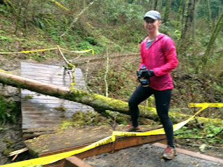
Coming off a few weeks of hellacious hill runs I wanted to run something familiar, for the most part we ran on Wildwood and Leif this week. I did throw in Upper Macleay to break up the return on Wildwood on the way back. And just for Susan I made sure we had to run up the to the Pittock Mansion at the end of our 14 miler. We were surprised to see the bridge that had been damaged a month ago had been completely rebuilt. I wish I could remember the mileage point on Wildwood of the bridge.  The damaged bridge on March 24 The rebuilt bridge 14 mile route start at Pittock Mansion Wildwood 3.75 -  6.45 Apsen: 2.7 Apsen to Thurman trailhead : .5 Leif 0 - 3.10 to Firelane 1 : 3.10 Firelane 1 - Wildwood : .53 Wildwood 11.25 - 5.10 to Upper Macleay : 6.15 Upper Macleay to Wildwood : .57 Wildwood 4.25 - 3.75 to Pittock .50 total: 14.05

Yakima Skyline Rim 25k

Image
Before the race Today Ann & I did the Yakima Skyline Rim 25k . I'd say we ran it, but with the exceptionally steep climbs and incredibly rocky, narrow, twisty and otherwise technical trails, we ended up walking about half the time. Bridge over Yakima River It was very sunny and exposed, so I ended up with a really odd tan: ankle to below the knee, and a pasty patch from my armband on my left arm. Luckily it wasn't windy, as it often is along those high ridges. Getting close to the top of the first climb The course was intense. After a tiny out and back from the starting line to help spread us out, we ran over a suspension bridge over the Yakima River, then under train tracks, and then straight up a 2100ft climb (note: felt like more than that to me!) on rocky, winding single-track. We made it! Nearly to the top, we turned onto a dirt road that evened out with some rolling hills. Finally, we had a steep decent almost back to the starting elevation before

Sunriver

Image
Amazing blue sky and snowy mountain view This weekend was a bit different-- with both of us in Sunriver, we took a shorter run-- tapering for next week's 25k-- around the paved trails of the resort. Despite the decreased distance, it felt really difficult, since we were at 4,300 ft. I told Ann to look tired

16.47 (BPA road)

Image
I had an easy time picking this route, since I knew I wanted to do the part of Wildwood from Germantown to Newberry-- we haven't been there for ages. BPA Road was at the perfect mile marker and offered one of those painful trips down the hills to Highway 30 that we need to knock off the list. BPA road started out from Wildwood (east to Highway 30) with rolling hills... then suddenly dropped away, steep with a wide open view of the Willamette River bending around Sauvie Island and towards its meeting with the Columbia River. It was so clear that we could see Mt St Helens, Rainier, Adams, and Hood. The view was breathtaking. Then, at the bottom of the hill, we had to turn around and come back up. Again, breathtaking! Even walking up, it was so steep that we could barely catch our breath. Although I'm not in a hurry to run the bottom part of BPA again, I'd be happy to go down to where the view starts. The rest of the run was good-- there are still lots of downed trees, but