Posts

Showing posts from July, 2013

Running in pain

Image
I knew there was a marathon taking place in Forest Park on Saturday, so I planned a route trying to avoid most of the marathon traffic. I was hoping for an uneventful, mellow 22 miles for our last long run before our Epic Lady Mountain Run (circumnavigating Mt. Hood). For the most part we did avoid most of the marathon, but uneventful it wasn't.  Susan managed to roll her ankle (the stronger one, which is fine). She tripped on a root and started flapping her arms, which luckily helped her not land on her face. Around mile 18 Susan screamed and started waving her arms in the air like a crazy person, then I felt an intense pain in my left pinky. I looked around and realized we were surrounded by yellow jackets, and I yelled, "GO!". We ran fast and got the hell out of there. Susan got stung on her arm and I did on my pinky finger, the pain we felt from the bites for the rest of the run was worse than any pain I have ever felt running. I will have to remember this ...

Manzanita Beach

Image
Manzanita Beach is known for being one of the longest beaches on the Oregon coast, at seven miles long. On a weekend visit to Manzanita, I decided to run part of the beach instead of my usual Cape Falcon route. Usually I head south, where the bulk of the beach lies. This time, however, I ran north towards Neahkahnie Mountain and into the headwind, thinking that I'd have a nice tailwind on my way back. Manzanita Beach at the base of Neahkahnie Mountain I ran as far as possible to the north, which felt quite tough against the wind, then turned around and headed south. That part of the run felt good. I was speedy, not out of breath, and it was easy to enjoy the gorgeous scenery. Then I had to turn around again to head back to my starting point. The wind was so strong that I felt like I was standing still. My clothes and gear flapped, threatening to fly off me. I laughed, because the run was as flat as could be, but here was something approximating elevation gain: a strong he...

Michigan Family 18 Miler

Image
Trail log at one of the North Country Trail trailheads  My step brother Noel and I flew to Michigan this weekend to visit my dad, Gretchen and step mom Stephanee. Since we are a family of runners, I said I would come up for the weekend if they would run 18 miles with me, as part of my training for circumnavigating Mt. Hood. Of course without hesitation Dad and Noel agreed. Noel and Me Noel ready to leave the road for the trails It had been a few years since I had seen Noel and since then he has become a pretty accomplished trail runner. I had a great time discussing running, races, gear and nutrition, we even talked about doing a fast packing trip in a few years. Chasing dad down the boardwalk self portrait  Dad and Stephanee live on Gun Lake in Michigan which is surround by Yankee Springs Recreation Area , which has a lot of running and biking trails and also hooks up with the larger North Country Trail system. Dad had several ideas on routes but i...

Lucky Mt Hood 26 miler

Image
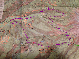
To get in a run at altitude, and for a change of scenery, Ann planned a day-off run for us up on Mt Hood. It was also a chance for us to try out gear for our circumnavigation of Mt Hood: a water pump, folding poles, and food. Hot from the start We started out near Riley Horse Camp, and ran a dry, sandy trail across the river and onto the Pacific Crest Trail, where the first of three major climbs began. Tiny wildflowers Bald Mountain was our first summit, which we ran last August . Of course Ann also ran it much more recently . Crossing the Sandy-- a rare bridge I remembered that climb well, so I wasn't surprised when the two and a half miles seemed to really stretch out. At the top of Bald Mountain, the sweeping view of Mt Hood and alpine meadows makes the memory of the climb melt away. One of three total bridges Then there are the river crossings, which were much easier with the poles. Of course, the Mt Hood Scramble last year gave us lots of experien...

Solo Bald Mountain

Image
Mt Hood from the top of Bald Mountain  The 13+ mile Bald Mountain - Ramon Falls loop has to be one of favorite (to date) runs close to Portland, Susan and I first did this run last August. You get a little bit of everything: a good hill climb, spectacular views of Mt. Hood, alpine meadows, intense glacial river crossing and a 120 foot waterfall. I was a little nervous doing the run solo, knowing that the Muddy Fork river was going to be raging with all the snow melt off and you have to cross it twice! I also knew this was a good chance to run with my new poles and to get a little bit of training on the Timberline trail in preparation for our run around Mt. Hood in August. It took me a bit of time at each of the river crossing to find a good place to cross, the water was up to my knees, but I would not of been able to do it without my poles. I came across a group of backpackers after the 2nd crossing and they asked me how the crossings were, and I replied tha...

Does this run make me look hot?

Image
Saturday was one of the hottest days of year so far in Portland and we decided to run 20 miles (12 for Dana). Luckily the shade of the tress helped keep us a little cooler, as did running next to Balch Creek . Sign post at the Macleay parking area We broke the run into 2 parts, the first part was 12 miles for Dana and the second part was 8 miles, so we could get our 20 miles in.   We started at the Macleay parking lot off NW Cornell and headed down Wildwood to Aspen, and looped around on Leif Erickson to Firelane 1 and back to Wildwood. The 2 nd part of the run was a “simple” out and back on Wildwood between mile makers 5 and 1. Simple if you like running hills, which I do. That 4-mile stretch is probably the hilliest part of Wildwood, you run up to the Pittock and back down and then up to Washington Park and the Zoo, and then we had to turn around and do it again. We don’t run this section of Wildwood very much; it was nice to see everything in bloom at the Pittock...